Government and international experts discussed the importance of Integrated Geospatial Information Management for sustainable development

The National Agency for Geospatial Development (ADE, IP) held a High-Level Leadership Consultation Meeting on Thursday, March 27. The initiative was part of the Regional Forum on Strengthening Geospatial Information Management Mechanisms and Accelerating the Implementation of the Sustainable Development Goals (SDGs) that took place in Maputo throughout the week.
At the opening session of the event, the Secretary of State for Transport, Chinguane Mabote, considered the initiative “of extreme relevance for global development and for Mozambique, in particular, given its vastness, territorial extension, great ecological and socio-economic diversity, since geospatial technologies represent a powerful tool for facing structural challenges and driving inclusive growth”.
According to the same official, in recent years, Mozambique has “witnessed significant advances in the use of geospatial data, from environmental monitoring, land use, to natural disaster risk management”. “The ability to collect, analyse and apply geospatial data is crucial to saving lives, protecting critical infrastructure and improving community resilience”, highlighted Chinguane Mabote, stressing, however, the existence of many challenges in this area, “including the need to strengthen technical capacities, ensure interoperability and accessibility of data, promote systems integration and ensure sustainable investments in technological infrastructure”.
The event was organized by internationally renowned institutions such as the United Nations Global Knowledge and Innovation Centre (UN-GGKIC), the SDG Data Alliance, the Committee of Experts on Global Geographic Information Management of the United Nations Secretariat (UN-GGIM), the Regional Committee for Africa and its Secretariat at the Economic Commission for Africa (ECA), in partnership with the National Agency for Geo-Spatial Development, Public Institute (ADE – IP).
Odete Semião, Director General of ADE, highlighted that “the effective use of geospatial information allows us to improve decision-making, optimize resources and promote fundamental actions that contribute to poverty reduction, gender equality, access to quality education and protection of the country”. However, she acknowledged that “there are still obstacles to be overcome, especially in the strengthening of data infrastructure, collaboration between different sectors and educational access to information”.
The same person in charge hopes that “this moment of collaboration between the countries present, international organizations and experts will be fundamental for sharing knowledge and
build a robust and effective approach to geospatial data management, based on mutual understanding and respect for the diverse realities of the region”.
Geospatial information plays a crucial role in implementing the United Nations 2030 Agenda, enabling more effective and inclusive planning. In her speech, Catherine Sozi, UN Resident Coordinator for Mozambique, argued that the country “is at a more advanced level in geospatial technology”, but that it still needs to do more and better, affirming the United Nations’ willingness to provide the necessary support. “This is a very important aid for the Government, but above all for the communities, to better plan for the future, such as knowing where to build their houses, where to plant seeds, in other words, it helps us to have less devastating impacts whenever a cyclone or other natural phenomenon occurs”, highlighted the official.
The meeting brought together representatives of government institutions and international agencies, senior staff and experts to discuss advances, challenges and opportunities in the management of geospatial information, with the main objective of aligning efforts to strengthen integrated information management mechanisms and public digital infrastructure.
Outras noticias
policy
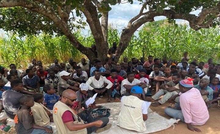
Escalating tensions in Nangada worsen the humanitarian crisis in the north of the country
2026-05-07

policy
Former Presidents with Million-Dollar Salaries from the State: Government Confirms Privileges Equivalent to the Head of State
2026-05-07
policy
The government considers a gradual increase in fuel prices inevitable
2026-05-07
Society
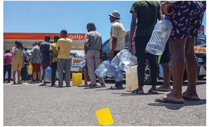
Yellow Card to the Mozambican Government for the Poor Management of the Fuel Crisis: From Fuel Shortages to a Crisis Exposing the Fragility of the State
2026-05-07

Society
Absa's Ready to Work program mobilizes over 14,000 young people and enters a new phase
2026-05-06
Copyright Jornal Preto e Branco All rights reserved . 2025